₹15,500
Summer / Autumn
Trek Distance: 46 Km
Trip Duration: 5 Days
Trek Difficulty: Difficult
Experience: Advanced Beginner
Pickup & Drop: Badrinath
Satopanth Lake Trek
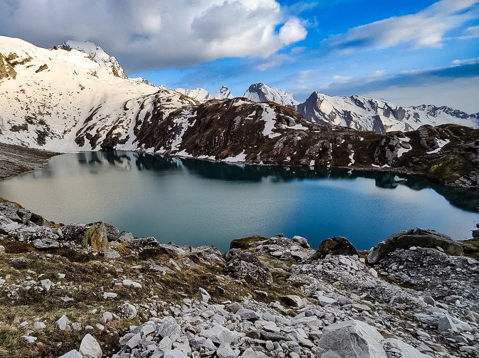
Satopanth Lake Trek is a beautiful trek full of excitement that starts from the Badrinath and goes to the holy Satopanth Lake, the source of the sacred Alaknanda River. As its name suggests, the meaning of ‘Satopanth’ – Sato (meaning: Truth) + Panth (meaning: Way/Path), is “Path of truth”! Satopanth Lake is a beautiful green triangular-shaped lake situated on the banks of Satopanth Glacier, between the east side of the Chaukhamba and the west of the Neelkantha Peaks. Satopanth Lake Trek is considered a very sacred journey in Hinduism.
As per Hindus text, the Trio Lord Brahma, Lord Vishnu, and Lord Shiva did penance on the banks of Satopanth lake. Because of this, the lake holds a sacred and significant place in Hinduism. Apart from this, people believe that one can travel to heaven through this path. After the end of Mahabharata in Dwapar Yuga, Pandavas and Draupadi set out on this route to travel to heaven. Out of which, only Yudhishthira was able to complete this journey successfully.
Satopanth Glacier Trek / Swargarohini Trek / Satopanth Swargarohini trek
Alternatively, Satopanth Lake Trek is also called Satopanth Glacier Trek/Swargarohini Trek/Satopanth Swargarohini trek. The Satopanth Glacier originates from the southeast of the Chaukhamba peak. Near its origin, the glacier looks like stairs, which is called ‘Swargarohini’! Swargarohini is around 5 km ahead of Satopanth Lake.
Surya Kund
Surya Kund is a small pond, which lies about one and a half kilometers from Satopanth Lake towards Swargarohini.
Vishnu Kund
Vishnu Kund is 1 kilometer furthermore from the Surya Kund. It is a bit difficult to reach this place and becomes more difficult towards the Swargarohini.
Best Time to Visit Satopanth Lake Trek
May, June, Sept, Oct.
Satopanth Lake Trek Starting point
Badrinath, Chamoli, Uttarakhand, PIN – 246422.
Sort Itinerary
- Rishikesh
- Badrinath
- Laxmi Van
- Chakrateerth
- Satopanth
- Chakrateerth
- Laxmi Van
- Badrinath
- Rishikesh
Itinerary for Satopanth Lake Trek
Day 1: Rishikesh To Badrinath - Pickup From Joshimath
- Distance - 294 Km
- Driving Time - 11 Hrs.
- Maximum Altitude - 3124m
For Joshimath, you will get a lot of public transport from Rishikesh Haridwar, and many taxis are also available there for booking. The journey from Rishikesh to Joshimath is about 260 km, which is first on the banks of the river Ganges and then later on the banks of the Alaknanda. The whole journey is full of joy and excitement. There are beautiful mountains, jungles, villages, confluences of rivers on the way. After you reach the Joshimath, we will pick you up for Badrinath from there. Overnight stay will be at Badrinath.
Day 2: Badrinath To Laxmivan
- Distance - 10 Km
- Trekking Time - 6 Hrs.
- Maximum Altitude - 3654m
- Altitude Gain - 530m
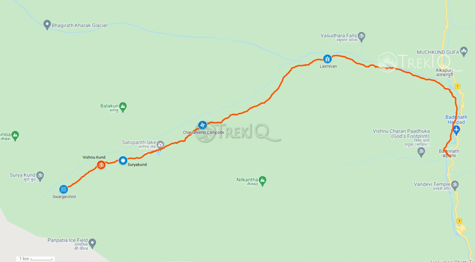
Our trekking will start from Badrinath Guest House. After having the darshan of Badrinath Lord, we will proceed towards Laxmi Van. After walking about 3 km from the temple along the banks of river Alaknanda comes Mata Murti Temple, opposite Mana Village. As we proceed from here, the climb starts increasing, and the trail passes through many landslides. After some time, we see the beautiful Vasundhara Falls on the other side of the river.
The climb progresses slowly till the arrival of Samtoli Bugyal. After crossing the Boulder section, we reach the Laxmi Van campsite, where we see Bhojpatra trees on the banks of the river Alaknanda. Today we will rest the night in Laxmi Van. The snout of the Satopanth Glacier and Bhagirathi Glacier is visible from the Laxmi Forest Campsite and in the middle of which the Balakun Mountain attracts attention.
Day 3: Laxmivan To Chakrateerth Via Sahastradhara Waterfall
- Distance - 7 Km
- Trekking Time - 4 Hrs.
- Maximum Altitude - 4216m
- Altitude Gain - 562m
After the start of a beautiful morning, we will proceed towards Chakrateerth Campsite. The trail is more challenging as we ascend towards the Chakrateerth. There are lots of boulders, steep ascents, and many water streams on the way. When we reach Sahastradhara, there are dozens of water streams and small waterfalls falling from the mountain, looks splendid. You can observe many small caves and shepherd huts throughout the trail. One can comfortably stay or go camping in the caves near Sahastradhara. After crossing boulders-filled paths and small glaciers, we reach Chakratirth. From Chakrateerth you can view Neelkanth, Chaukhamba and Balakun peaks.
Day 4: Chakrateerth To Satopanth Lake To Vishnu Kund Then Back
- Distance - 11 Km
- Trekking Time - 7 Hrs.
- Maximum Altitude - 4530m
- Altitude Gain - 314m
Today’s hike is not so steep, and it’s a bit easier to climb today. Also, we will camp at the same site today, so no need to carry extra luggage, carry only essentials with you. Satopanth Lake is only 3 km away from Chakrateerth. You need to cross two small glaciers or ice debris emerging from the west ridge of Nilkantha Parvat to reach Satopanth Lake. After that, we see the triangular Shaped Satopanth Lake. The elevation of Satopanth Lake is around 4350m/14272ft.
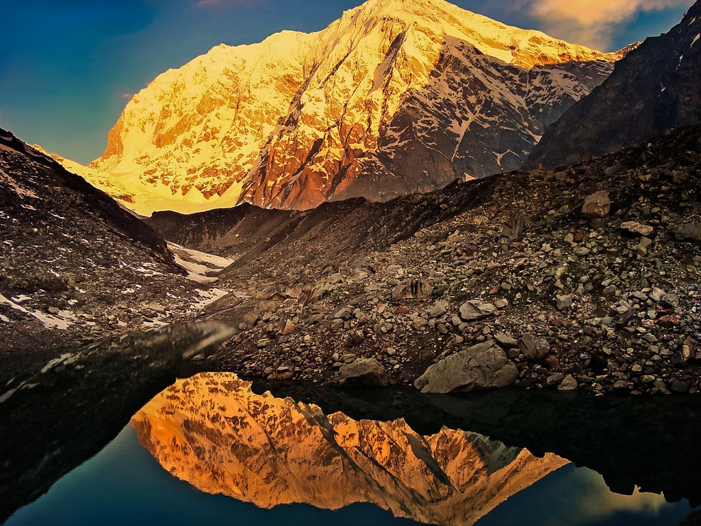
The reflection of mount Chaukhamba in the lake is very charming, especially in the morning and evening when the Sun spreads the red spectrum in the sky, as you can see in the trip photo. So plan your trekking accordingly. Do meditation for a while, and you will feel calm and relaxed. The lake of Satopanth is very holy, so do not spread the dirt in the lake or around the lake. Be responsible and keep the Himalayas clean.
We can also proceed to Surya Kund, Vishnu Kund, or Swargarohini to see Chaukhamba and Swargarohini up close. Due to an extreme lack of oxygen and bad trails, trekking further becomes difficult. After that, we will go back to the Chakrateerth campsite.
Day 5: Chakrateerth To Laxmivan
- Distance - 7 Km
- Trekking Time - 3 Hrs.
- Altitude - 3654m
Now we will descend back to the Laxmivan. The descent will be easy today. You can enjoy yourself at the Sahastradhara waterfall.
Day 6: Laxmivan To Badrinath
- Distance - 10 Km
- Trekking Time - 5 Hrs.
- Altitude - 3124m
Today we will descend back from the Laxmivan campsite towards Badrinath. From where we will go to the Joshimath via taxi. We will stay at the Joshimath.
Day 7: Badrinath To Rishikesh (Joshimath Drop)
- Distance - 294 Km
- Driving Time - 11 Hrs.
From Joshimath, you get plenty of transportation options for the Rishikesh, Haridwar, and Dehradun. You can choose public transport or book a taxi. It will take around 9-10hr to cover the 260km distance for Joshimath to Rishikesh.
SatopanthTrek Price
₹15,500 Inc GST – Badrinath to Badrinath
Inclusion
- Accommodation Hotel/ Guesthouse/ Tents
- Meals as per itinerary
- Safety Equipment (oxygen cylinder, first ad...)
- Tour Guide.
- Trekking Gears like Crampons, Gaiters (When needed).
- Forest entry charges, permits & camping fee.
- Necessary Permit
Exclusion
- Porter/Mule charges for carrying personal luggage.
- Any costs arising out of unforeseen circumstances like landslides, roadblocks, bad. Weather, etc.
- Trekking Gears like poles, shoes, poncho etc.
- Travel Insurance.
Things to carry
- Waterproof Trekking Shoes
- Woolen/Cotton Socks (Thick) - 3-4 Pairs
- Woolen sweater ( warm & Light )
- Jacket/Windcheater
- Trek Pants/Lower - 2 units
- Thermal wears - 2 pairs
- Full Cotton T-shirts - 2-3 units
- Inner wears - 2-3 Pairs
- Gloves
- Sun cap
- Woolen cap
- Warm woolen shawl ( Thin & Light )
- Water Proof Rucksack ( 30-60 liter )
- Rain coat/Poncho
- Rain cover for your bag
- Portable Tourch/Headlamp
- Sunglasses
- Water Bottle
- Toiletries
- Winter Moisturizer Cream
- Lip Balm
- Sunscreen Lotion
- First Ad Kit ( ORS, AMS tablets, Band Ad, Pain Relief Spray, Coldarin, etc.)
Satopanth Lake Trek FAQs
According to Hindu legends and mythology, Tridev(Supreme Gods), Brahma, Vishnu, and Mahesh (Lord Shiva) had meditated at the three corners of this lake. In Hindu belief, it is auspicious to take a bath in the Saptopanth lake on the 11th day (Ekadashi) of the Sun and Moon Paksha. People believe that the Trimurti takes a holy dip in the Satopanth lake’s waters during every Ekadashi. Locals believe that some unique birds around the Satopanth lake keep this lake clean, and these birds are sacred Gandharvas who keep the lake away from all dirt and evils.
According to the Mahabharata, Pandavas went to heaven from the Swargarohini(Stairway to Heaven). Only Yudhishthira had succeeded in going to heaven through Swargarohini. People believe that Pandavas went on a journey to heaven from this path only.
The ‘Satopanth’ consists of two words: ‘Sato’ (meaning: Truth) + ‘Panth’ (meaning: Way/Path). which combined meaning is “Path of truth”!
The location of Satopanth Lake is in the Chamoli district of Uttarakhand, near Mana Village.
The nearest bus stop and taxi stand are in Badrinath. You can reach Badrinath from Rishikesh, Haridwar, and Dehradun via public transport, private vehicles, and taxies. You can reach Rishikesh, Haridwar, and Dehradun via trains and buses from other states. There is also an airport in Jollygrand Dehradun, which connects with the metro cities of India.
Months of May-June and September-October are the best to visit Satopanth Lake Trek.
Yes! You must have some experience above the 3000m trek. You need to be physically fit before attempting the Satopanth Lake trek.
We have placed the Satopanth Lake trek at a difficulty level of 2. In this trek, one has to cross many landslides, boulders, and small glaciers. Apart from this, the high altitude and low oxygen level make this trek difficult.
The total trek length of the Satopanth Lake Trek is between 40-50 km. It varies accordingly with the trekking points you cover. If you trek only up to Satopanth Lake, then it will be around 40km trek. If you go beyond the lake, it will be up to 50 km or 50+ km trek.
You need 4-5 days to complete Satopanth Lake Trek from Badrinath to Badrinath.
Absolutely can be. Badrinath, our base camp, has an altitude of more than 3100 meters above sea level. While going to an elevation of more than 3000 meters increases the chances of getting AMS. As we proceed towards Satopanth lake, the altitude reaches up to 4400 meters. Therefore high chances of occurring of AMS.
Acclimatization is the process in which an individual organism adjusts to a change in its environment, allowing it to maintain performance across a range of environmental conditions. Acclimatization occurs in a short period and within the organism’s lifetime. Wikipedia
We can observe acclimatization when traveling to high-altitude locations, such as tall mountains. For instance, if an individual hikes to 3,000 meters above sea level and stays there for 1-3 days, they become acclimatized to 3,000 meters. If the same person hikes to 4000 meters in altitude, their body has to acclimatize once again. Some of the changes that take place during acclimatization to high altitudes involve:
- Increased production of Red blood cells.
- Increased pressure in pulmonary arteries – thereby forcing blood into sections of the lungs that are usually not used during normal breathing at lower altitudes.
- Increased depth of respiration.
- Increased depth (volume) of breath.
In some cases, individuals suffer from Acute Mountain Sickness when ascending to elevations of over 3,000 meters from sea level. However, it is a common and mild condition. If the body gets enough time, then it can be overcome. It happens due to reduced air pressure at high altitudes as well as lower oxygen levels. One of the more severe forms of mountain sickness is called High Altitude Cerebral Edema, where fluid builds up in the brain. It is a life-threatening situation and requires immediate medical attention.
Satopanth Lake Facts
Latitude & Longitude
30.743474°N 79.357369°E
Max Altitude
4350 m / 14272ft
Total trek distance
40-50 Km
Difficulty Level
Difficult Level 2
Trip Duration
7 Days 6 Nights
Pickup & Drop
Rishikesh/Joshimath
Group Size
4-15
Age Group
12-60
Essential facts
Nearest Medical Facility
Badrinath
Nearest Hospital
Joshimath
Nearest ATM
Badrinath
Mobile Connectivity
Badrinath
Last Electricity
Badrinath
Nearest Bus Station
Badrinath
Nearest Railway Station
Rishikesh
Nearest Airport
Dehradun

You must be logged in to post a review.
Similar Treks..
- -5%
Spiti Valley Exploration Tour
-
₹20,999Original price was: ₹20,999.₹19,999Current price is: ₹19,999. - Book Now This product has multiple variants. The options may be chosen on the product page
Kagbhusandi Lake Trek
- ₹16,500
- Book Now
- Rated 5.00 out of 5


Satopanth Lake Trek Reviews
There are no reviews yet.